The data preprocessor class, SoTVizDataPreprocessor , is able to read and process multiple and different elevation file formats.
Input elevation file formats supported are:
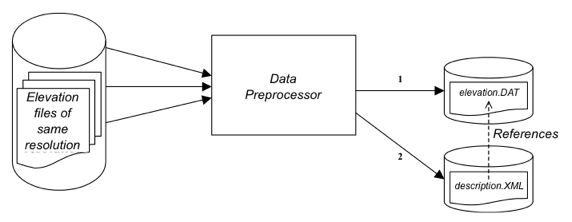
Elevation files can cover overlapping geographic zones, but must be of the same resolution. Missing data to fill up the resulting .dat file will be set to zero. This class outputs a single “.dat” elevation file and fills the XML file with the information related to elevations. Then this XML file can be loaded by an SoTVizRender node.
![[Important]](../../images/important.jpg) | |
The data preprocessor class requires that the supplied input files be of the same resolution. If there are different resolutions, the first input file resolution is taken as reference. |