The preprocessing classes of TerrainViz, deriving from SoTVizPreprocessor , import GIS file formats which can be DEM (Digital Elevation Model) file format (DTED, STDS,…), geo-referenced raster file format (GeoTiff…), or raster file format with geo-referencing information (JPEG, TIFF, GIF,...).
All these GIS file formats store elevation or localization data using the Geodetic Reference System. Thus, the preprocessing classes must convert from a geodetic coordinate system (longitude, latitude or projected coordinates in the geodetic reference system) to the Open Inventor world coordinate system (a Cartesian coordinate system).
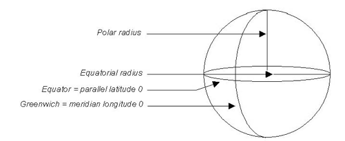
This reference system approximates the earth dimensions with an ellipsoid and a patch called Datum which gives the orientation and the position of this ellipsoid relative to the real center of the earth.
The ellipsoid is defined by two values: the equatorial radius (ER) and either polar radius (PR), inverse flattening (1/F), or eccentricity (E). Those two last values can be computed from radius values through the following formulas:
Flattening F = 1 – PR/ER
Squared Eccentricity E ² = 2F – F ²
Different universities, laboratories, and topography organizations have computed different ellipsoid models and Datum models which correspond to different regions of the Earth. In other words, in order to reduce the gap between the approximation model and the reality, each country has one or more Ellipsoid and Datum models.
![[Important]](../../images/important.jpg) | |
The positions are commonly expressed as UTM, x/y/z or latitude, longitude, elevation triplets. |
The Ellipsoid models supported by TerrainViz are the following:
|
|
The Datum models supported by TerrainViz are the following:
|
|
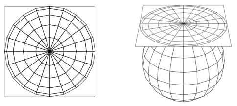
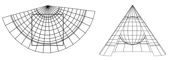
Each portion of the surface of the Earth stored within GIS files is a planar map. Obviously this means that the curvilinear Earth surface is projected onto a plane.
As you can imagine, such a projection involves some distortion in the planar representation. There are different kinds of projections from the curvilinear earth surface to a plane. Each of these projections has properties which reduce the distortion issues according to the position on the earth of the projected area.
The following are the projections supported by TerrainViz.
|
|